Ireland, often celebrated for its lush green landscapes, also holds within its terrain dramatic evidence of a colder past. The phrase “Irish glacial valley” conjures images of sculpted landscapes, carved by the immense power of ice ages long gone. These valleys, with their distinctive forms and rich geological history, offer a fascinating glimpse into the forces that shaped the Emerald Isle. Let’s delve into the world of Irish glacial valley facts and answer some frequently asked questions about these remarkable features.
Unveiling the Glacial Valleys of Ireland
The impact of past glaciations is etched across the Irish landscape, and numerous valleys bear the unmistakable signature of glacial erosion. These Irish glacial valley formations are primarily found in mountainous regions, where ice accumulated and flowed with immense force.
What are the glacial valleys in Ireland?
Ireland boasts several prominent glacial valleys, each with its unique character and scenic beauty. Some notable examples include:
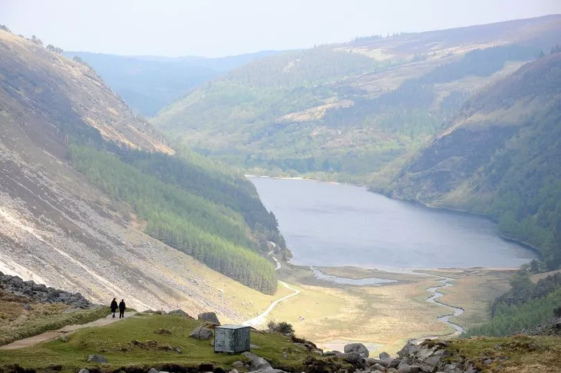
- Glendalough Valley: Perhaps the most famous, renowned for its stunning scenery and monastic site.
- Glenveagh Valley: Located in County Donegal, part of Glenveagh National Park, showcasing a dramatic U-shaped profile.
- The Wicklow Mountains valleys: Numerous valleys within this range, including Glenmalure and the Sally Gap area, exhibit clear glacial features.
- Valleys in the MacGillycuddy’s Reeks: Home to Ireland’s highest peaks, this range in County Kerry features deeply carved glacial valleys.
Locating these features is made easier with an “Irish glacial valley map,” which highlights the regions most affected by past glaciation.
Are there any glaciers in Ireland?
The answer to “Are there glaciers in Ireland” is no, not in the present day. The last glacial period ended around 10,000 years ago, and the ice sheets that sculpted the Irish glacial valley landscapes have since melted. While corrie glaciers (small, bowl-shaped glaciers) may have persisted slightly longer in sheltered high-altitude areas, Ireland’s climate is now too mild to support permanent ice.
Is Glendalough a glacial valley?
Yes, Glendalough Valley is a classic example of a U shaped valley in ireland formed by glacial erosion. The broad, steep sides and relatively flat floor are characteristic features of valleys carved by ice. The powerful glaciers that once flowed through this region sculpted the landscape we see today. You can easily locate this stunning area on a “Glendalough Ireland map.”
Why is Glendalough famous?
What is Glendalough famous for extends beyond its glacial origins. While its dramatic Glendalough Valley scenery is a major draw, it is equally renowned for its well-preserved early Christian monastic settlement, founded by St. Kevin in the 6th century. The combination of breathtaking natural beauty and significant historical and archaeological sites makes Glendalough a truly unique and captivating destination.
What is the younger Dryas in Ireland?
The Younger Dryas was a geologically recent period of abrupt climate cooling that occurred in the Northern Hemisphere, including Ireland, between approximately 12,900 and 11,700 years ago. Following a period of warming after the main glacial period, the climate temporarily reverted to glacial conditions. In Ireland, this likely led to the re-advance or still-stand of some ice, further shaping the existing Irish glacial valley landscapes and influencing vegetation patterns.
Where are glacial valleys located?
Generally, glacial valleys are located in mountainous regions that experienced significant ice accumulation during glacial periods. The weight and movement of these massive ice sheets carved out existing river valleys, transforming them into the characteristic U-shape. In Ireland, as mentioned earlier, prominent Irish glacial valley formations are found in the Wicklow Mountains, the mountains of Donegal, and the MacGillycuddy’s Reeks in Kerry.
What are the two fold mountains in Ireland?
Ireland’s geology is complex, but the primary examples of fold mountains are the ranges in the southwest, particularly in County Kerry and County Cork. These mountains, including the MacGillycuddy’s Reeks and the Comeragh Mountains, were formed by tectonic forces that folded and uplifted rock layers. While glaciers have significantly shaped these ranges, their initial formation was due to folding, not glacial activity.
Where are drumlins in Ireland?
Drumlins are elongated, oval-shaped hills formed by glacial deposition. They are composed of unsorted glacial sediment (till) and are typically aligned with the direction of ice flow. Ireland has a significant number of drumlin fields, particularly in counties Cavan, Monaghan, Leitrim, and Down. These areas were under the ice sheet during the glacial periods, and the retreating ice deposited the till in these characteristic landforms. While not valleys, drumlins are another prominent feature of Ireland’s glaciated landscape.
What are drowned glacial valleys called?
Drowned glacial valleys that have been flooded by the sea are called fjords or sea lochs. While Ireland doesn’t have classic, deep fjords like Norway or New Zealand, some coastal inlets and bays, particularly along the western and northern coasts, exhibit features suggestive of glacial erosion that were subsequently inundated by rising sea levels after the ice melted.
How can you tell if a valley was formed by a glacier?
Several key features indicate that a valley was formed by a glacier:
- U-shape: Glacial erosion tends to create broad valleys with steep, straight sides and a relatively flat bottom, unlike the V-shape carved by rivers. This is a defining characteristic of a U shaped valley in ireland.
- Hanging valleys: Tributary valleys that enter the main glacial valley high above the valley floor.
- Truncated spurs: Ridges of land that have been cut off by the erosive power of the main glacier.
- Striations and grooves: Scratches and grooves on the bedrock caused by rocks embedded in the moving ice.
- Moraines: Deposits of unsorted glacial sediment (till) left behind by the glacier.
- Cirques: Bowl-shaped, amphitheater-like depressions at the head of a glacial valley, where the glacier originated.
What is the difference between a cirque and a glacial valley?
A cirque is the bowl-shaped hollow at the head of a glacial valley, where a glacier typically originates through snow accumulation and ice formation. A glacial valley, on the other hand, is the larger, U-shaped valley carved by the glacier as it flows downhill from the cirque. The cirque is the source area, while the glacial valley is the pathway carved by the moving ice.
Why is it called hanging valley?
A hanging valley is a tributary valley whose floor is significantly higher than the floor of the main valley it flows into. This occurs because the larger glacier in the main valley erodes more deeply than the smaller glacier in the tributary valley. When the ice melts, the tributary valley is left “hanging” above the main valley, often resulting in waterfalls.
The Enduring Legacy of Ice: Exploring Ireland’s Glacial Valleys
The Irish glacial valley landscapes stand as a testament to the powerful forces of nature and the dramatic changes Ireland has undergone over millennia. From the iconic Glendalough Valley, rich in both natural beauty and history, to the dramatic U shaped valley in ireland formations found throughout the mountainous regions, these features offer a unique window into the island’s geological past. Understanding the Irish glacial valley facts and appreciating the processes that shaped them enriches our understanding of Ireland’s diverse and captivating terrain. While “Are there glaciers in Ireland” today is a resounding no, the sculpted valleys remain as enduring reminders of a colder, icier era.